Herramientas de usuario
Barra lateral
benitagla:portada
El espacio de nombres
benitagla:lugares no existeBenitagla
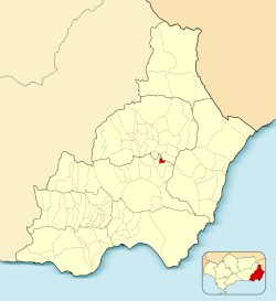
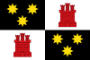 | BENITAGLA |  |
||||||||||
| Información | ||||||||||||
|---|---|---|---|---|---|---|---|---|---|---|---|---|
| Fundación: | Siglo VIII | |||||||||||
| Coordenadas: | 37°13′54″N 2°14′20″O | |||||||||||
| Altitud: | 945 m | |||||||||||
| Comarca: | Tabernas-Filabres | |||||||||||
| Distancia a la capital: | 60 km | |||||||||||
| Gentilicio: | Benitaglero o benitaglense | |||||||||||
| Patrón: | - | |||||||||||
| Patrona: | Virgen de la Piedad | |||||||||||
 |
||||||||||||
operating instructionsVarious functions are available as part of the map. mouse/touch operation
keyboard operationKeyboard operation becomes available after activating the map using the tab key (the map will show a focus indicator ring).
It's possible that some of the functions or buttons describe above have been disabled by the page author or the administrator
|
||||||||||||

Warning, the folder related to namespace benitagla:galeria does not exist.
Tradiciones y festividades
Información adicional
benitagla/portada.txt · Última modificación: por bastetani